Troubled borders
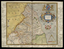
In the north, the defence of England's Scottish border was a constant concern for Elizabeth I. This map of Northumbria comes from an atlas of English and Welsh counties belonging to the queen's chief minister, William Cecil, Lord Burghley.
Burghley was acutely aware of the political value of maps. Under his supervision, Christopher Saxton produced 34 coloured maps of the counties, starting in the early 1570s with Norfolk. Saxton's drawings were engraved by some of the best craftsmen of the day, among them, Leonard Terwoort, Remigius Hogenbergius and Nicholas Reynolds. As each plate was finished, proof copies were sent to Burghley for his immediate use.
The notes around the edges of this map are written in Burghley's own hand. Under the heading "Names of ye principal lordships in the Middle March with the lords names", he lists manors belong to "the Queen's majesty", including Tynmouth, Harthill, Humbleton and Barrington, and those of powerful lords such as the Earl of Northumberland, Sir Thomas Grey and Robert Delaval, whose manor of Seaton Delaval could be counted on to raise "30 horses".
The complete set of maps was published in 1579 and dedicated to the queen. Saxton's maps set the standard, both in accuracy and detail, for succeeding county maps over the next century and more.