The bottom line
The first stage in meeting the French challenge was to lay out a baseline from which a network of triangles could be extended through Greenwich and on to the Kent coast, from where it would be linked across the Channel to the triangulation of northern France.
William Roy chose Hounslow Heath as the most convenient location for setting out the baseline. In spring of 1784, troops were detailed to clear a five-mile stretch across the heath from King's Arbour to the Hampton Poor House, just outside Bushey Park. A preliminary measurement of the straight line between these two points was made the following month, using a steel chain.
Work continued throughout the summer, attracting much public attention. Refreshment tents were pitched on site to cater for the numbers who came to see for themselves the ingenious means by which Roy contrived to measure the baseline to an unprecedented level of accuracy. Among the distinguished visitors was George III, who had a life-long fascination with scientific instruments.
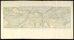
This hand-drawn plan of the position of the Hounslow Heath baseline comes from Roy's own 'Account of the measurement of the base on Hounslow Heath...', presented to the Royal Society in 1785.